
Parcel 12-2N-24-1640-0015-0000
Owners
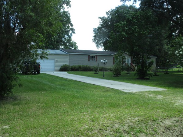
35559 GLORY RD
CALLAHAN, FL 32011
Parcel Summary
| Situs Address | 35559 GLORY RD |
|---|---|
| Use Code | 0200: MOBILE HOME |
| Tax District | 6: Drainage Dist |
| Acreage | 1.0000 |
| Section | 13 |
| Township | 2N |
| Range | 24 |
| Subdivision | PERRET PLANTATION #1 |
| Exemptions | HX: Homestead (196.031(1)(a)) (100%) HB: Homestead Banded (196.031(1)(ab) (100%) |
Short Legal
LOT 15PERRET PLANTATION PHASE #1
PB 6/144-145
Certified Values
| STANDARD | 2024 |
|---|---|
| Land Value | $30,000 |
| (+) Improved Value | $176,708 |
| (=) Market Value | $206,708 |
| (-) Agricultural Classification | $0 |
| (=) Assessed Value | $161,299 |
| (=) County Taxable Value | $111,299 |
Document/Transfer/Sales History
| Instrument / Official Record | Date | Q/U | V/I | Sale Price | Ownership |
|---|---|---|---|---|---|
| SW 2329/0884 | 2019-12-27 | Q | Improved | $182,000 | Grantor: REAL EST PRO OF N FL LLC & TAYLOR ROSE LLC Grantee: GARNER CODY & SANDRA |
| SW 2291/1678 | 2019-07-19 | U | Improved | $77,500 | Grantor: FADER ENTERPRISES LLC Grantee: REAL EST PROS OF N FL LLC & TAYLOR ROSE LLC |
| SW 2291/1629 | 2019-06-27 | U | Improved | $81,000 | Grantor: SELENE FINANCE LP Grantee: FADER ENTERPRISES LLC |
| CT 2268/0126 | 2019-04-04 | U | Improved | $81,000 | Grantor: CLERK OF COURT Grantee: SELENE FINANCE LP |
| QC 1527/0097 | 2007-09-25 | U | Improved | $100 | Grantor: GURLEY HOYT L & SARAH C Grantee: GURLEY HOYT L ETAL |
| QC 1524/1049 | 2007-09-11 | U | Improved | $100 | Grantor: GURLEY HOYT L & SARAH C Grantee: GURLEY HOYT L & SARAH C & STEVEN CRISLER |
| WD 1499/1501 | 2007-05-17 | U | Improved | $100 | Grantor: GURLEY HOYT L & SARAH C Grantee: CRISLER STEVEN J L/E |
| WD 0913/1800 | 2000-01-03 | U | Vacant | $27,500 | Grantor: M E PERRET INC Grantee: GURLEY HOYT L & SARAH C |
Buildings
Building # 1, Section # 1, 164044, MOBILE HOME
| Heated Sq Ft | Year Built | Value |
|---|---|---|
| 1836 | 1999 | $195,120 |
Structural Elements
| Type | Description | Code | Details |
|---|---|---|---|
| EW | Exterior Wall | 30 | VINYL |
| RS | Roof Structure | 03 | GABLE/HIP |
| RC | Roof Cover | 03 | COMP SHNGL |
| RC | Roof Cover | 12 | MODULAR MT |
| IW | Interior Wall | 05 | DRYWALL |
| IF | Interior Flooring | 14 | CARPET |
| IF | Interior Flooring | 08 | SHT VINYL |
| AC | Air Conditioning | 03 | CENTRAL |
| HT | Heating Type | 04 | AIR DUCTED |
| BDR | Bedrooms | 3.00 | |
| BTH | Bathrooms | 3.00 | |
| FR | Frame | 02 | WOOD FRAME |
| STR | Stories | 1. | 1. |
Extra Features
Land Lines
Personal Property
None
TRIM Notices
Property Record Cards
Disclaimer
The Nassau County Property Appraiser's Office makes every effort to produce the most accurate information possible. No warranties, expressed or implied, are provided for the data herein, its use or interpretation. The information contained herein is for ad valorem tax assessment purposes only. The Property Appraiser exercises strict auditing procedures to ensure validity of any transaction received and posted by this office but cannot be responsible for errors or omissions in the information received from external sources. Due to the elapsed time between transactions in the marketplace, and the time that those transactions are received from the public and/or other jurisdictions, some transactions will not be reflected.